The Gran Plaza in Tikal, Guatemala, is a space that is unusual in many regards. I will mention just two. The first is that it survives, or is revived, as a social space. Tikal is the ruin of a Mayan city that was effectively abandoned in the ninth century. The continuing, albeit limited, use of the Gran Plaza is very interesting. On Christmas day I saw many Guatemalan families (they appeared to be Mayan) picnicking or otherwise relaxing in the Gran Plaza (see the video of groups using this space, http://www.youtube.com/watch?v=fBIz6-XhN5w). Jeff, the friend with whom I was traveling, approached the plaza at a different time that same day. He said that before he got to it, he could hear a hubbub coming from the Gran Plaza.
The second way in which it is unusual is physically. The proportions of the square are much different from what I would expect in a US or European city (which is mostly what I have experienced). The volume defined by the structures is more vertical. The Gran Plaza is defined by two pyramid-shaped temples to the east and west and two complexes of smaller buildings to the north and south. The space between the temples' steps, the part closest to the other, is approximately 200 feet, as is the distance between the rises to the north and south (see the plan of the Gran Plaza, with the defined square highlighted in gray). The temples themselves had risen (there has been more or less loss of height over the last thousand years) almost 150 feet.
(Compare the heights and distances between structures with the Parque Central in Antigua, for example. The latter has four times the surface area of the Gran Plaza and is surrounded mostly by two-story buildings (see http://andrewvesselinovitch.blogspot.com/2010/12/guatemalas-rich-public-places-antiguas.html).)


 The pyramids of Tikal are composed of three sections (see the first and last photos, of Temple I and Temple II, respectively). The base occupies the lowest part of the pyramid and is the largest section. The actual temple is a much smaller section that sits on top of the base. The top of the pyramid is the roofcomb, which is often taller than the temple.
The volume of the plaza may have an unusual cultural (if intentionally done) or poetic (if not) meaning. The base of Temple I is built in nine levels. According to Mayan scholar Mary Ellen Miller, this "probably refer(s) to the nine levels of the Mesoamerican underworld, where a king would descend to its nadir, only to rise up once again" (Maya Art and Architecture, p. 40). The arrangement of the structures around the Gran Plaza implies, in volume, an inverted base of a pyramid that is as tall as the others, but with a "platform" (the ground) much larger than any of them (see the east-west section through the Gran Plaza and the panoramic photo from the south).
The platform is where the temple rests. If the ground level of the Gran Plaza is the platform of an implied inverted base, the pyramid's "temple" would be underground. The trip to the underworld begins right here, under our feet.
For some of the background material for this post, I must thank two resources: Tikal: Guia de las Antiguas Ruinas Mayas (1971) by William R. Coe; and Maya Art and Architecture (1999), by Mary Ellen Miller.
 Sunday afternoon, the day after Christmas, I saw Antigua's Parque Central in full-force. Hundreds of people were there in the hour before sunset, listening to music, eating food from vendors, and in general seeing and being seen (see a snippet of the crowd listening to a Spanish version of "Jingle Bells", http://www.youtube.com/watch?v=8X7hry4dOtA). This was the Latin American square I had heard about and had not before seen. I returned a few times and the park was always busy (see a video of the park at night, with only Christmas lights for illumination, filled with conversation, http://www.youtube.com/watch?v=4dMBcBmlU-I).

What made Parque Central so active? Certainly, Guatemalan society must be predisposed to public socializing. The square also has a number of fine design and programming elements that support its use as a communal living room.
William Whyte, in his observations of public spaces, proposed that a number of elements must be present for them to be successful. These include water, food, seating, and what he called "triangulation", or some sort of attraction that can create a bond between strangers. The Parque Central has these elements.

 On Sunday afternoon the entire western edge of the park grounds was lined with food vendors. At other times, there were at least ice cream vendors. These latter would contribute to the aural environment of the square through their bells (see video of the park as seen from the cathedral porch, with the ambient sound of the vendors, http://www.youtube.com/watch?v=iu3u_GW4ClY
).
The seating in and around the square is abundant and, in one particular instance, ingenious. The Palacio del Ayuntamiento (city hall), at the east end of the north side of the square, is raised above the park and has a covered arcade in front of it. Both features are exploited for seating.
Within the arcade and against the wall of the building is an almost continuous stone bench. It provides a covered and shaded resting spot from which to watch the activities in the square. To reach the arcade from the street, there are a few steps. Unshaded, but closer to the action in the square, the stairs are also used for seating (see the last two photos).
The triangulation is a bit harder to measure and is, in part, cultural. What may pique one person's interest may be different from another's. On Sunday, in addition to the band and food, there were horse rides available and an itinerant clown. There is also the beauty and the activity of the cathedral, to the east of the park, city hall, and the attraction of the businesses on the north and west sides.
While this spot has been a public place since the founding of Antigua in the 16th century, until the 20th it had been a hardscape. Only in the last century did it acquire vegetation, the most recent incarnation of the park having been executed in the 1990s. The presence of trees for shade, at a minimum, makes the Parque Central a more welcoming place for recreation than it would have been without them.
 Whatever its past, the Parque Central is now, though design, commercial use, and cultural attitude towards public recreation, a very successful place. Maybe we can emulate it to create good public places in the United States.
Some of the background information on the park I found in the following two publications: "Antigua Guatemala: The city and Its Heritage", by Elizabeth Bell, and "Antigua: Su Historia, Monumentos, Personajes, Sucedidos y Leyendas", by Rafael Alvarez Polanco.

 Guatemala City's bazares navideños, or Christmas markets, are another example of how simple changes to public spaces can make them more sociable. As part of the Paseo de la Sexta project, a decision was made to move street vendors from Sixth Avenue (Avenida Sexta). Since street vendors are often not valued by authorities, I wondered -- Would they have a place where they could succeed and from which the broader community would benefit?The design of the market and its location are very good. As in Paseo de la Sexta, simple and low-cost materials are well-used. The market is defined by banners and brightly-colored fabric suspended from scaffolding. The fabric makes some shade, can be seen from a distance, and becomes a "roof", defining the market space beneath it (see top photo and video, http://www.youtube.com/watch?v=Q-5FaYvRl-U, of the market along 19th Street).
The market also straddles the city's new Transmetro bus station at Plaza Barrios (see bottom photo). Transmetro buses draw passengers because they run faster than traditional Guatemala City ones, in part because the stops are less frequent. This feature concentrates more passengers at fewer stops, giving the market the advantage of having a larger number of people in the vicinity.
The station is also attractive and has a physical presence, unlike typical bus stops, giving the market an added legitimacy.The answer to my questions is "yes".

 The
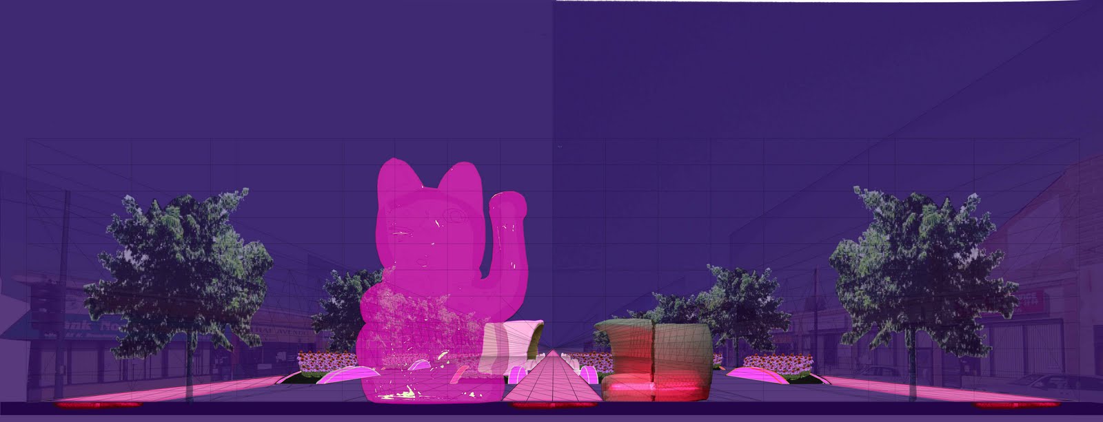
The  intersection of Broadway and Clarendon Avenue in Chicago's Lakeview is like many in the United States -- excessively wide and unsafe. It is also an unused opportunity to create a social space, or at least a more pleasing looking one, in an urban environment.
In a "Y" intersection, such as this one, traffic engineers usually give motor vehicles as much space to maneuver as possible (see middle left photo of the truck and bicycle in a sea of asphalt). This does a disservice to everyone on the road -- motorists, pedestrians, and bicyclists. It becomes unclear who is to go where and also encourages higher speeds, a dangerous combination.
Tighten it up! By narrowing the "Y" to a "T" intersection and bringing out the sidewalk to the vehicle (motor and foot-powered) travel lanes, everyone benefits (see my plan, bottom left). Paths are clearer, speeds are reduced, and pedestrians have less asphalt to cross.
Landscape it! Program it! Let it be! This newly found space (shown in red in the plan), in a fairly densely settled neighborhood, can now become an urban living room. Landscaped, it can be more visually appealing. Hardscaped, it could be used for farmers markets or impromptu shows and hula-hooping (see image, top left).
 The Gran Plaza in Tikal, Guatemala, is a space that is unusual in many regards. I will mention just two. The first is that it survives, or is revived, as a social space. Tikal is the ruin of a Mayan city that was effectively abandoned in the ninth century. The continuing, albeit limited, use of the Gran Plaza is very interesting. On Christmas day I saw many Guatemalan families (they appeared to be Mayan) picnicking or otherwise relaxing in the Gran Plaza (see the video of groups using this space, http://www.youtube.com/watch?v=fBIz6-XhN5w). Jeff, the friend with whom I was traveling, approached the plaza at a different time that same day. He said that before he got to it, he could hear a hubbub coming from the Gran Plaza.
 The Gran Plaza is defined by two pyramid-shaped temples to the east and west and two complexes of smaller buildings to the north and south. The space between the temples' steps, the part closest to the other, is approximately 200 feet, as is the distance between the rises to the north and south (see the plan of the Gran Plaza, with the defined square highlighted in gray). The temples themselves had risen (there has been more or less loss of height over the last thousand years) almost 150 feet.

 The pyramids of Tikal are composed of three sections (see the first and last photos, of Temple I and Temple II, respectively). The base occupies the lowest part of the pyramid and is the largest section. The actual temple is a much smaller section that sits on top of the base. The top of the pyramid is the roofcomb, which is often taller than the temple.